Principal meridian
Jump to navigation
Jump to search

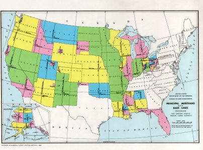

This BLM map depicts the principal meridians and baselines used for surveying states (colored) in the PLSS.
In the United States of America Public Land Survey System, a principal meridian is the meridian line used for survey control in a large region, and which divides townships between east and west. The meridian meets its corresponding baseline at the point of origin, or initial point, for the land survey. For example, the Mount Diablo Meridian, used for surveys in California and Nevada, runs through the summit of Mount Diablo.
Often, meridians are marked with roads, such as the Meridian Avenue in San Jose, California and Meridian Road in Vacaville, California, both on the Mount Diablo Meridian.