South Georgia

South Georgia is a large (3,756 square kilometres) mountainous Island in the far South Atlantic.[1] It is part of a British Overseas Territory with the Sandwich Islands.
The mountains valleys carry many glaciers. The coast is pierced by many fjords. Early in the 20th Century approximately a dozen of the fjords contained settlements that serviced fleets of whaling vessels. Most of the old whaling ports have been entirely abandoned. Grytviken is largely abandoned. But some buildings are kept in repair for visiting scientists and tourists.
The first explorer to land on South Georgia, and start to map its coast was James Cook.[1]
Polar explorer Ernest Shackleton is buried in Grytviken.[1]
South Georgia is a British Overseas Territory, administered from the Falkland Islands.
South Georgia was occupied by a token element of Argentinian ground forces, and scrap metal merchants, during the Falklands War.
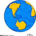
View of the Earth centred over South Georgia.
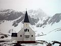
The church in Grytviken, South Georgia, one of the buildings kept in repair.
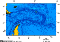
Drake Passage - Falklands - South Georgia - South Sandwich Islands.png


References
- ↑ Jump up to: 1.0 1.1 1.2 Astronaut Photography of Earth - Display Record: ISS011-E-12148, NASA, August 26 2005. Retrieved on 2008-04-25.