File:GPLed Grand River.png: Difference between revisions
Jump to navigation
Jump to search
imported>George Swan (== Summary == {{Image notes |Description=Grand River, Ontario |Author=User:George Swan |Date=2004 October 29 |Source=self-made |Country first published in=Canada |Copyright holder=User:George Swan |Notes=This map was created using [http://www.aquarius.ifm-geomar.de/omc/ this tool]. |Other versions=}}) |
imported>George Swan m (more details) |
||
| Line 10: | Line 10: | ||
|Notes=This map was created using [http://www.aquarius.ifm-geomar.de/omc/ this tool]. | |Notes=This map was created using [http://www.aquarius.ifm-geomar.de/omc/ this tool]. | ||
|Other versions=}} | |Other versions=}} | ||
Here are the longitudes and latitudes I used to create this map: | |||
* -80.30,43.90,[[Grand Valley]] | |||
* -80.362,43.70,[[Fergus, Ontario|Fergus]] | |||
* -80.45,43.68,[[Elora, Ontario|Elora]] | |||
* -80.49,43.46,[[Waterloo, Ontario|Waterloo]] | |||
* -80.42,43.48,[[Bridgeport, Ontario|Bridgeport]] | |||
* -80.45,43.44,[[Kitchener, Ontario|Kitchener]] | |||
* -80.32,43.38,[[Cambridge, Ontario|Cambridge]] | |||
* -80.38,43.20,[[Paris, Ontario|Paris]] | |||
* -80.26,43.13,[[Brantford, Ontario|Brantford]] | |||
* -79.8573,42.9538,[[Cayuga, Ontario|Cayuga]] | |||
* -79.61,42.90,[[Dunnville, Ontario|Dunnville ]] | |||
* -79.56,42.86,[[Port Maitland, Ontario|Port Maitland]] | |||
== Licensing/Copyright status == | == Licensing/Copyright status == | ||
{{Dual-CC-by-sa-3.0-GFDL}} | {{Dual-CC-by-sa-3.0-GFDL}} | ||
Revision as of 16:13, 24 November 2007
Summary
Summary
Here are the longitudes and latitudes I used to create this map:
- -80.30,43.90,Grand Valley
- -80.362,43.70,Fergus
- -80.45,43.68,Elora
- -80.49,43.46,Waterloo
- -80.42,43.48,Bridgeport
- -80.45,43.44,Kitchener
- -80.32,43.38,Cambridge
- -80.38,43.20,Paris
- -80.26,43.13,Brantford
- -79.8573,42.9538,Cayuga
- -79.61,42.90,Dunnville
- -79.56,42.86,Port Maitland
Licensing/Copyright status
File history
Click on a date/time to view the file as it appeared at that time.
| Date/Time | Thumbnail | Dimensions | User | Comment | |
|---|---|---|---|---|---|
| current | 19:53, 11 March 2022 | 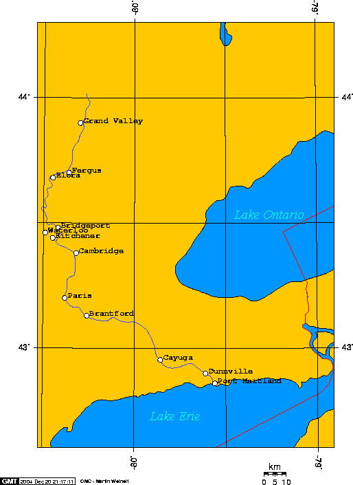 | 514 × 705 (10 KB) | Maintenance script (talk | contribs) | == Summary == Importing file |
You cannot overwrite this file.
File usage
The following 2 files are duplicates of this file (more details):
- File:Map of Grand River, Ontario.png from a shared repository
- File:Map of Grand River, Ontario.png from Wikimedia Commons
The following 4 pages use this file: