File:Approximate area of the Niagara Escarpment 2.PNG: Difference between revisions
Jump to navigation
Jump to search
imported>George Swan (== Summary == {{Image notes |Description=Approximate area of the Niagara Escarpment |Author=User:George Swan |Date=2005 January 6 |Source=self-made |Country first published in=Canada |Copyright holder=User:George Swan |Notes=This map was created using [http://www.aquarius.ifm-geomar.de/omc/ this tool]. |Other versions=}}) |
imported>George Swan m (more details) |
||
| Line 8: | Line 8: | ||
|Country first published in=Canada | |Country first published in=Canada | ||
|Copyright holder=[[User:George Swan]] | |Copyright holder=[[User:George Swan]] | ||
|Notes=This map was created using [http://www.aquarius.ifm-geomar.de/omc/ this tool]. | |Notes=This map was created using [http://www.aquarius.ifm-geomar.de/omc/ this tool], and then modified by hand, by me, to reproduce the information on [http://www.uwgb.edu/dutchs/geolwisc/niagesc.htm this page]. | ||
|Other versions=}} | |Other versions=}} | ||
== Licensing/Copyright status == | == Licensing/Copyright status == | ||
{{Dual-CC-by-sa-3.0-GFDL}} | {{Dual-CC-by-sa-3.0-GFDL}} | ||
Revision as of 15:59, 24 November 2007
File history
Click on a date/time to view the file as it appeared at that time.
| Date/Time | Thumbnail | Dimensions | User | Comment | |
|---|---|---|---|---|---|
| current | 19:55, 11 March 2022 | 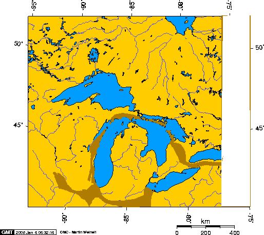 | 514 × 458 (30 KB) | Maintenance script (talk | contribs) | == Summary == Importing file |
You cannot overwrite this file.
File usage
The following 2 files are duplicates of this file (more details):
- File:Approximate area of the Niagara Escarpment 2.PNG from a shared repository
- File:Approximate area of the Niagara Escarpment 2.PNG from Wikimedia Commons
The following 2 pages use this file: