File:US Secession map 1865.svg
Jump to navigation
Jump to search


Size of this PNG preview of this SVG file: 800 × 495 pixels. Other resolution: 2,560 × 1,583 pixels.
Original file (SVG file, nominally 959 × 593 pixels, file size: 80 KB)
Summary
| Description |
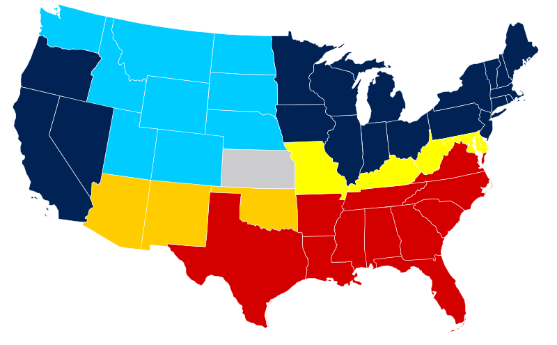
United States map of 1865, show affiliation of states and territories regarding the Secession War (Civil War.) Legend: Union states Union territories not permitting slavery Border Union states, permitting slavery Bleeding Kansas, entered Union Confederate states (all of which permitted slavery) Union territories permitting slavery |
|||
| Date | ||||
| Source |
|
|||
| Author | Júlio Reis |
Licensing
This file is licensed under the Creative Commons Attribution-Share Alike 3.0 Unported license.
- You are free:
- to share – to copy, distribute and transmit the work
- to remix – to adapt the work
- Under the following conditions:
- attribution – You must give appropriate credit, provide a link to the license, and indicate if changes were made. You may do so in any reasonable manner, but not in any way that suggests the licensor endorses you or your use.
- share alike – If you remix, transform, or build upon the material, you must distribute your contributions under the same or compatible license as the original.
|Author=Tintazul
derivative works
Derivative works of this file: Missouri Compromise Line.svg
File history
Click on a date/time to view the file as it appeared at that time.
| Date/Time | Thumbnail | Dimensions | User | Comment | |
|---|---|---|---|---|---|
| current | 14:07, 16 February 2011 | | 959 × 593 (80 KB) | imagescommonswiki>Holly Cheng | last version won't thumbnail; recreated from File:Blank US Map.svg |
File usage
The following file is a duplicate of this file (more details):
- File:US Secession map 1865.svg from Wikimedia Commons
There are no pages that use this file.