File:Thames River, London, Ontario (21834591351).jpg

Original file (3,920 × 2,940 pixels, file size: 7.28 MB, MIME type: image/jpeg)
.jpg)
Summary
| Description |
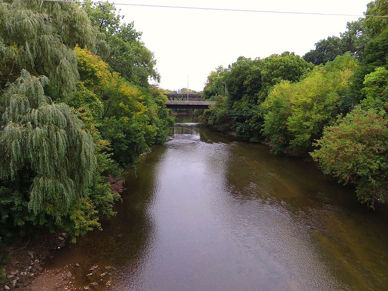
The Thames River is located in southwestern Ontario, Canada. The Thames flows west 273 kilometres (170 mi)[3] through southwestern Ontario, through the cities of Woodstock, London and Chatham to Lighthouse Cove on Lake St. Clair. Its drainage basin is 5,825 square kilometres (2,249 sq mi). Called Askunessippi (Anishinaabe language: Eshkani-ziibi, "the antlered river") by the Odawa and Ojibwa inhabitants, who together with the Neutrals have lived in the area since before Europeans arrived, the river was named after the River Thames in England by Lieutenant Governor John Graves Simcoe in 1793. Much of the Thames is surrounded by deciduous Carolinian forests, although much of this forest has been removed to permit agriculture and other forms of development. Three separate dams are used to control seasonal flooding in the watershed: Wildwood Dam, Pittock Dam and the Fanshawe Dam. There are three rivers in the watershed with Thames in the name — the Thames River itself, North Thames River, and Middle Thames River. These are also known locally as South Branch, North Branch, and Middle Branch. The South Branch is the main stem Thames River and officially carries the Thames River name. The Thames River and North Thames River on the upper part of the watershed flow through valleys created during the retreat of the glaciers during the last ice age. The Thames River and North Thames River meet in London at the forks; the University of Western Ontario is located on the North Thames River. Downriver from London, the lower part of the river flows through a shallow plain of sand and clay, with an average depth of 4 feet (1.2 m). The lower Thames River flows through Delaware, Chatham, Thamesville, as well as Chippewa and Oneida First Nations settlements. Tributaries of the Thames include the Avon River, Dingman Creek, Jeanettes Creek, McGregor Creek, Medway Creek, Pottersburg Creek, Stoney Creek, Trout Creek and Waubuno Creek. The river was the location of an important battle of the War of 1812. The Battle of the Thames (also known as the Battle of Moraviantown) was fought on October 5, 1813, between American General William Henry Harrison and British General Henry Proctor, along with Proctor's ally Tecumseh. Chief Tecumseh was killed in the battle. en.wikipedia.org/wiki/Thames_River_(Ontario) en.wikipedia.org/wiki/Wikipedia:Text_of_Creative_Commons_... |
| Date | |
| Source | Thames River, London, Ontario |
| Author | Ken Lund from Reno, Nevada, USA |
| Camera location | | View this and other nearby images on: OpenStreetMap |
|---|
.jpg¶ms=042.980447_N_-081.256595_E_globe:Earth_type:camera_source:Flickr_&language=en)
Licensing
- You are free:
- to share – to copy, distribute and transmit the work
- to remix – to adapt the work
- Under the following conditions:
- attribution – You must give appropriate credit, provide a link to the license, and indicate if changes were made. You may do so in any reasonable manner, but not in any way that suggests the licensor endorses you or your use.
- share alike – If you remix, transform, or build upon the material, you must distribute your contributions under the same or compatible license as the original.
| This image was originally posted to Flickr by Ken Lund at https://flickr.com/photos/75683070@N00/21834591351. It was reviewed on 19 December 2016 by FlickreviewR and was confirmed to be licensed under the terms of the cc-by-sa-2.0. |
File history
Click on a date/time to view the file as it appeared at that time.
| Date/Time | Thumbnail | Dimensions | User | Comment | |
|---|---|---|---|---|---|
| current | 10:01, 19 December 2016 | | 3,920 × 2,940 (7.28 MB) | imagescommonswiki>Mindmatrix | Transferred from Flickr via Flickr2Commons |
File usage
The following file is a duplicate of this file (more details):
.jpg)
- File:Thames River, London, Ontario (21834591351).jpg from Wikimedia Commons
The following page uses this file:
.jpg)