File:Civil war map.png: Difference between revisions
Jump to navigation
Jump to search
imported>Todd Coles ({{Image notes |Description= Map showing the Union and Confederate states during the US Civil War |Author= unknown |Date= unknown |Source= http://www.pdclipart.org/displayimage.php?album=47&pos=32 |Country first published in= |Copyright holder= Public Domain |Notes= |Other versions=}}) |
(== Summary == Importing file) Tag: Server-side upload |
||
| (One intermediate revision by one other user not shown) | |||
| Line 1: | Line 1: | ||
== Summary == | == Summary == | ||
Importing file | |||
Latest revision as of 19:55, 11 March 2022
Summary
Importing file
File history
Click on a date/time to view the file as it appeared at that time.
| Date/Time | Thumbnail | Dimensions | User | Comment | |
|---|---|---|---|---|---|
| current | 19:55, 11 March 2022 | 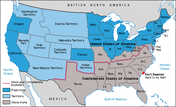 | 570 × 349 (11 KB) | Maintenance script (talk | contribs) | == Summary == Importing file |
You cannot overwrite this file.
File usage
The following 2 pages use this file: