File:Precipitation pH Map.png
Jump to navigation
Jump to search
No higher resolution available.
Precipitation_pH_Map.png (766 × 489 pixels, file size: 146 KB, MIME type: image/png)
Summary
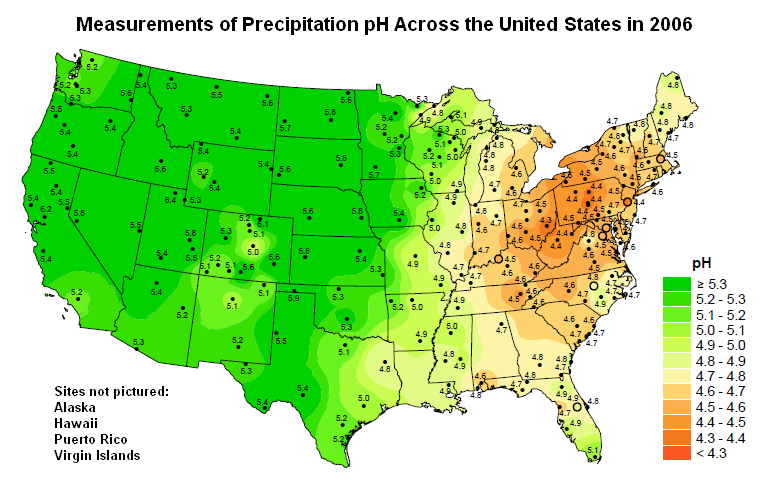
| Title / Description
|
Map of precipitation pH across the United States |
|---|---|
| Author(s)
|
National Atmospheric Deposition Program |
| Source
|
http://nadp.sws.uiuc.edu/lib/data/2006as.pdf (see page 10) |
| Date created
|
2006 |
| Country of first publication
|
United States |
| Notes
|
You can edit this page and add notes here which may be useful to people who wish to re-use this media. |
| Other versions
|
If there are other versions of this media on CZ, please list them here. |
| Using this image on CZ
|
Copy the code below to add this image to a Citizendium article, changing the size, alignment, and caption as necessary.
|
Image issue? Contact us via the email below.
Please send email to manager A T citizendium.org .
Licensing/Copyright status
This media, Precipitation pH Map.png, is in the public domain
This work has been released into the public domain by its creator.
This applies worldwide and in perpetuity.
You may freely copy, distribute, display and perform this work, as well as make derivative and commercial works.
File history
Click on a date/time to view the file as it appeared at that time.
| Date/Time | Thumbnail | Dimensions | User | Comment | |
|---|---|---|---|---|---|
| current | 19:53, 11 March 2022 | | 766 × 489 (146 KB) | Maintenance script (talk | contribs) | == Summary == Importing file |
You cannot overwrite this file.
File usage
The following 3 pages use this file: